
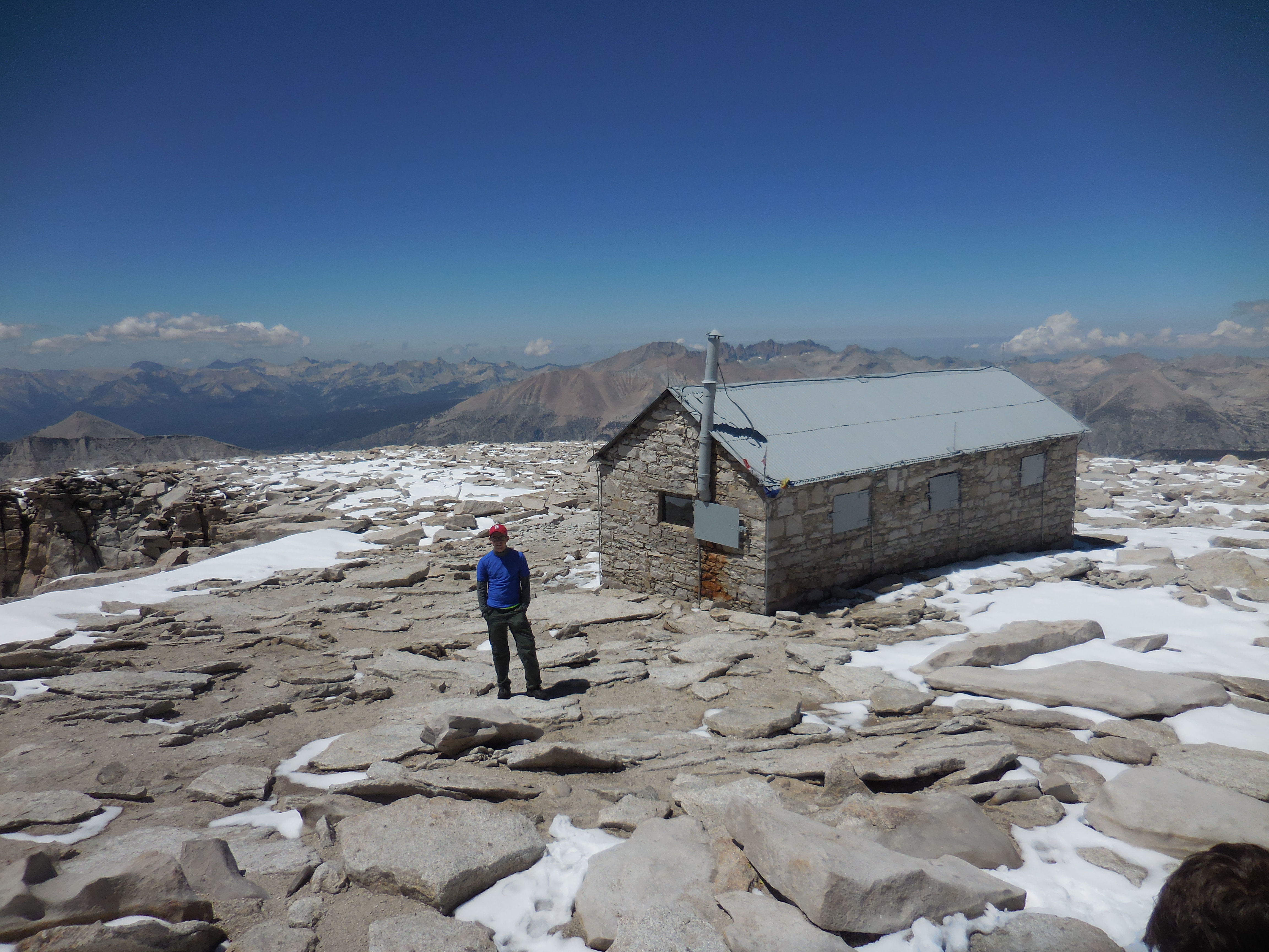
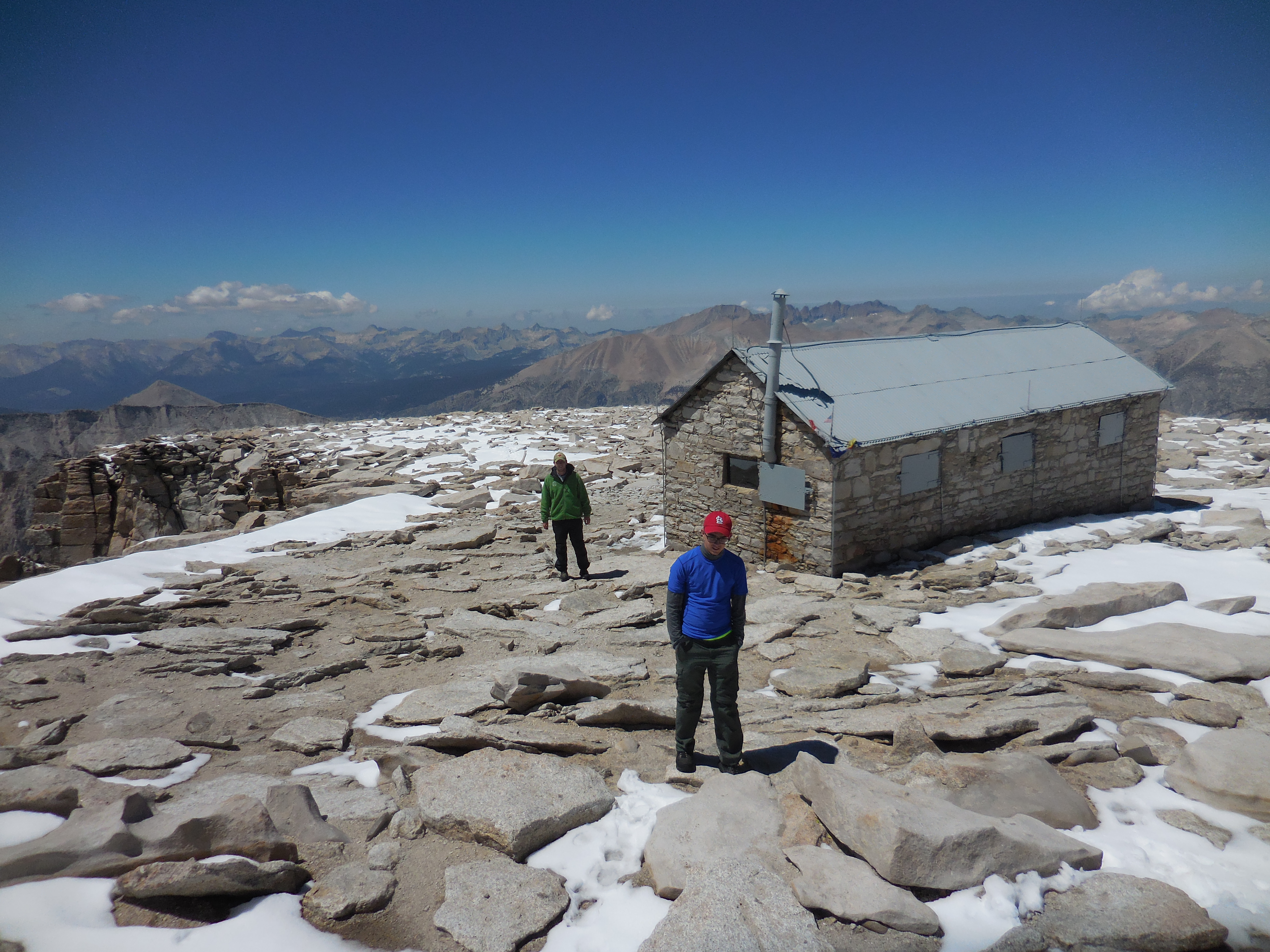
Whitney Summit - Elevation 14,505'
Whitney Summit - Elevation 14,505' |
 Clouds' Rest |
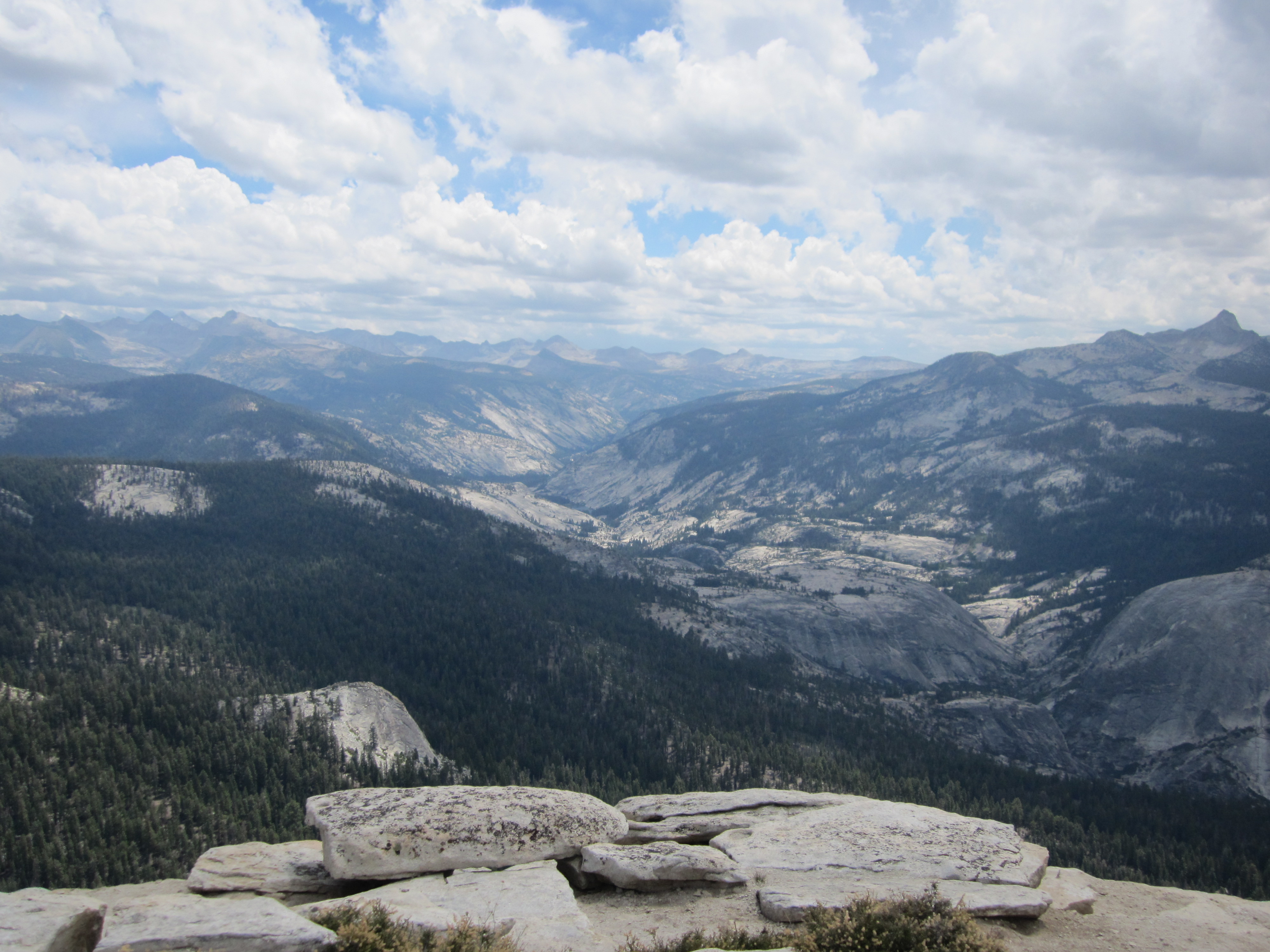
 Glacier Point |
 Death Valley Badwater Basin - 282 ft below sea level - awesome photo taken by Alex |
Drove from Santa Rosa to Bishop, stopping to hike up Lembert Dome near Tuolumne Meadows in Yosemite.
 |
 |
 |
Went from Bishop to Lone Pine, obtained Whitney Permit (and WAG bags, so we all could have bowel movements and pack the stuff out), then drove up to Whitney Portal campground. It was raining, and lots of small rocks were in the road at various places. After confirming our campsite was reserved, we drove back down. But now we found a boulder 1 to 2 feet across blocking the road, along with lots of smaller rocks. A car coming up had stopped.
We got out and started moving aside small rocks. Alex, Martin, and Ethan rolled the boulder out of the way. Then Martin and Bob rolled it a little further, except it rolled back on Bob's foot. Bob walked about cursing in pain, afraid foot was broken. Martin said he could drive a stick shift, so he took over and we found a clinic in Lone Pine. The nurse took one look at foot, touched it lightly with one finger, said they had no x-ray equipment in Lone Pine, but that the foot was fine and hiking the next day would not be a problem.
We decided to go to Death Valley, Martin driving, Bob in back seat with sock and shoe off hurt foot, resting it on console between front seats. Along the way we pulled off with another car to watch as two coyotes came up to the road, inspected us, then quietly walked back into the desert, clearly unconcerned. Here is a video of them.
 |
 |
Note that Bob has been to Death Valley twice in his life, and that both times it was raining. A careful statistical analysis of these data points shows that it rains every day in Death Valley. A surprising result.
| Our next stop was at some sand dunes in Death Valley. In these photos you can see Ethan and Alex trekking across the dunes, and all four in the final photo. |
|
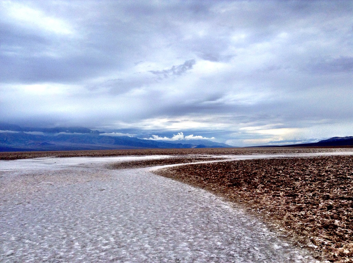
The next stop was Death Valley's lowest point - the lowest elevation in North America. The spectacular photo near the top of this page was taken by Alex. Click on the photo to see the original size.
We ended the day by driving back to Lone Pine, eating dinner, then going up to Whitney Portal campground, putting up tents and retiring for the night.
Today's goal was to reach Trail Camp, the last and highest of the camps before heading to the Whitney Summit. It is a 6.3 mile hike with a 3,640 foot elevation gain. Easily doable in one day. We took about 6 hours, largely because Bob goes uphill at about 1/2 the speed of the other three guys. On the other hand, this is a great way to prevent altitude sickness.
After packing the tents upon getting up, we started the day at the Whitney Portal Store by ordering a couple of the largest pancakes it is possible to buy. See photo below. Turned out the four of us could eat the equivalent of only one pancake, so we threw one away. The jays appeared to have figured this sort of thing happened regularly. We then assembled at the trail head and began our backpacking trip up Whitney.
 |
 |
 |
The weather was not working in our favor. It continued to rain, although drizzle might be a better description. This meant more water in the streams we had to cross and ultimately more snow and ice on the trail on the final ascent to Whitney. On the other hand, the clouds and fog on the peaks and cliffs made for some beautiful scenery.
Lone Pine Lake would be our first destination going up. To get there we had to cross a stream that Alex lent Bob a hand to get over. The stream and Lone Pine Lake are shown below. By this point, the packs were covered against the rain, although in Alex's case, he had already enclosed everything inside the pack with plastic bags.
 |
 |
 |
 |
We spent the rest of the hike passing pretty meadows, Mirror Lake, streams and waterfalls, as we climbed up towards Trail Camp. Saw marmots, and one pika, on the way, though the pika refused to get his picture taken. The rain stopped and the hike was pleasant. Here is a video of Trail Camp.
 |
 |
 |
 |
 |
 Mirror Lake |
 |
 |
 |
 |
|
 Going for it |
 Made it |
 Trail Camp, 12,000' elevation, 4.7 miles to summit |
Hiked and backpacked just under 16 miles - 4.7 miles and 2,500' elevation increase going up to the summit, then 11 miles all the way down to Whitney Portal campground, a drop in elevation of 6,200'.
Bob, the leader, planner, and experienced backpacker of the group awoke everyone at 5 AM, checked things out, and began the hike. About an hour into the hike, realized he was the only one who had brought no water at all. Fortunately, rest of group had sufficient water to share and did so.
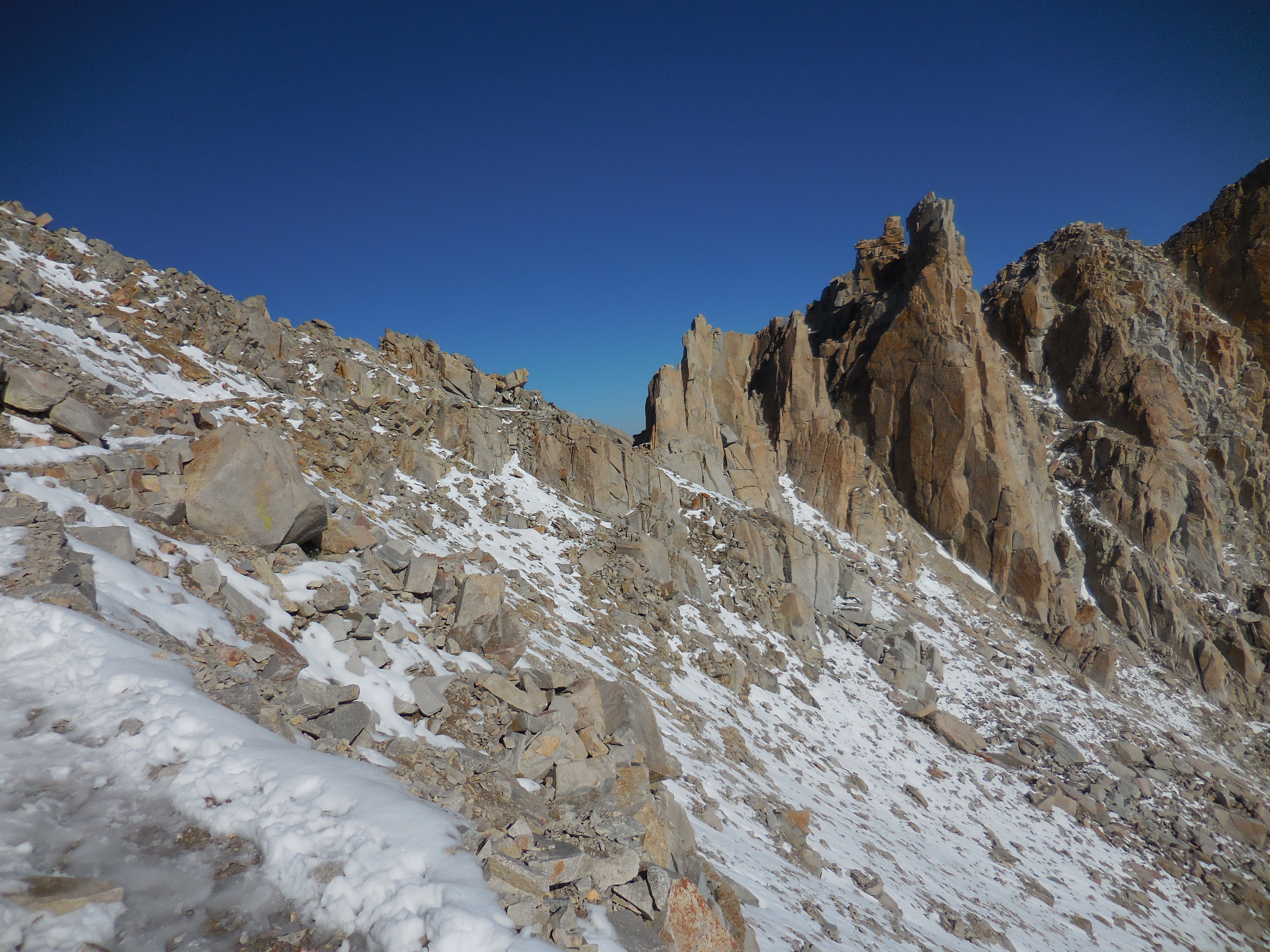
Hiked from Trail Camp to Trail Crest, at which point we were to decide whether to try for the summit. There had been snow for the last two days and a ranger yesterday had told a hiker it was dangerous to try and might even be more dangerous today with the sun out melting the accumulated ice and snow. A few days previously a 75 year old guy had died going to the Whitney summit.
When we got to Trail Crest, Bob's reaction was that it was too dangerous to keep going. The other three all felt we should at least begin the try, and if it really did become too dangerous, to head back. Meanwhile, we saw others start up the trail to the summit. Bob agreed to attempt the hike.
Here are videos above Trail Crest as we hiked up to the top:
 One of the few places with railings |
 Martin reaches Trail Crest |
 Alex reaches Trail Crest |
 Really (click on previous photo) |
 |
Why Bob was worried |
 |
 |
 |
 |
 |
Mt. Whitney Summit Hut - Destination in sight |
Click on photos below for full version
 |
 |
 |
 |
 |
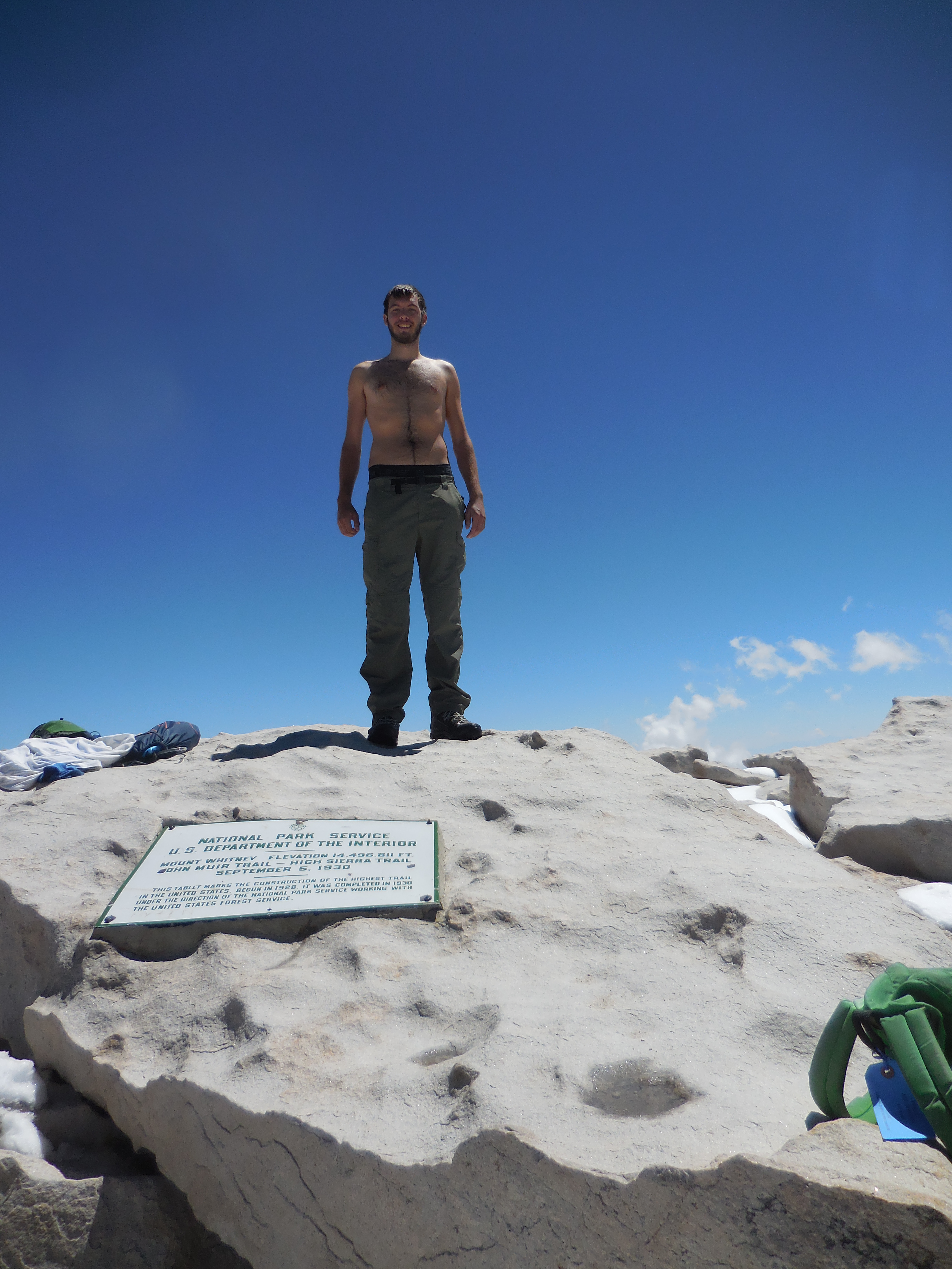
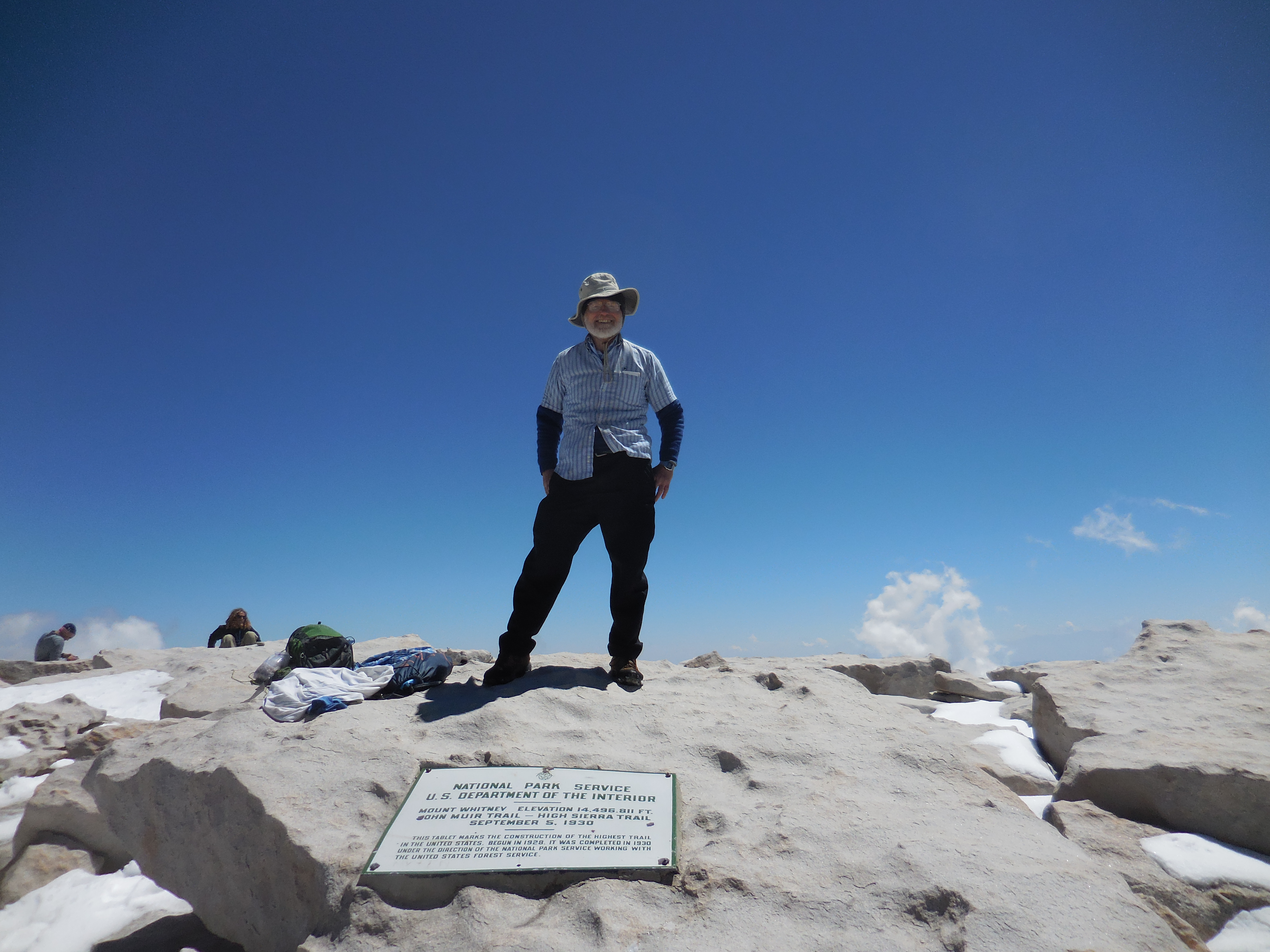
On Top Of Mt. Whitney |
After reaching the summit, signing the register at the hut, taking photos for other people, and harassing the 2 marmots (one fat and furry, the other skinny and scraggly), we hiked back down to our campsite, packed up, and hiked down to our Whitney Portal campsite, where we set up for the night.
Approaching Lone Pine Lake from above |
Our campground at Whitney Portal after the hike |
In the morning we drive down to Lone Pine Eastern Sierra permit office and obtain wilderness backpacking permit at 9:20 am. It would have been lost at 10 am.
Then we drive north to Lee Vining permit office to get canisters, because that is much closer to our starting point and we have to return canisters to the same office. We start our backpacking trip at Rush Creek with the goal of Clark Lake, Bob taking a bit more time to get started.
Along the way, a guy, Dave, is bringing down a couple of horses and a mule. Here is the video.
Clouds move in as Bob hikes and he hopes to make it to the trees at Agnew Lake before the precipitation begins. Just as he gets to the trees, the hail, sleet, and drizzle begin. Black trash bag goes over backpack, poncho goes over Bob, hike continues. Not all that pleasant, but not too bad.
Tough uphill climb out of Agnew Lake area, then Bob meets guys at top of climb in meadow just before Clark Lake. We decide to set up camp, get water, eat and go to bed.
 Ethan, Alex, and Martin start Rush Creek trail. |
 Guy named Dave bringing down horses and mule |
 Pumping pure water |
 Our campsite before Clark Lake |
Alex awakes early in the morning and talks with Bob about stomach problems, along with concern about his toe. Everyone gets up and we decide that Bob and Alex will head back to Rush Creek trailhead and take Alex to a clinic, then head back to Santa Rosa. Martin and Ethan will continue hiking towards Yosemite Valley. Martin and Alex both get maps of the route and we talk about options. Emergency/medical equipment, including the personal locator beacon which can call in a rescue crew and the water purifier, are taken by Martin.
Bob and Alex head back down the trail. It is pretty uneventful, though Alex does continue to suffer nausea. Here is a short video of Alex on the hike.
We pass parents and their daughters coming up the trail. One daughter is holding a baby turkey. It is not a wild caught turkey, but one that somehow got into their chicken area back home and was still too young to leave unattended. Once down, Bob and Alex went to the Lee Vining wilderness center, returned two canisters and were told to go to the clinic in Mammoth, south of Lee Vining and June Lake. The GPS led us to a wellness center, where we were told to go to the nearby hospital, which we did. Doctor said toe looks like it had just gotten over the infection and that the other symptoms could be giardia, but that would have been caught before the trip began (perhaps on an earlier rafting trip). Or it might not be giardia. In any case, if it did not clear up in a couple of days, Alex should see a doctor again. It cleared up.
The drive back to Santa Rosa was uneventful, except when a highway traffic guard stopping traffic asked us if we could transport a family of four hitchhikers a few miles down to Lembert Dome, where their tour bus would pick them up. Of course we said yes. The previous tour bus had broken down, all the other passengers had gotten onto a YARTS bus, leaving this family behind. The mother was from China and talked about the mountains there.
Meanwhile, Martin and Ethan hiked past Clark Lake, Thousand Island Lake over Donahue Pass to a meadow where they camped for the night. Here is a video from the campsite
 Baby Turkey Peep-Peep |
 Alex above Agnew Lake |
 Alex's toe after dropping cinderblock on it, climbing up and down Mt. Whitney, and backpacking up to near Clark Lake |
 Martin at 1000 Island Lake |
 1000 Island Lake |
 Two on the trail |
 |
 |
 Donohue Pass - Elevation 11,056' |
 Ethan in campsite after Donohue Pass |
 Martin's dinner |
Martin and Ethan hike down Lyle Canyon, then back up to Evelyn Lake.
 Path and meadow along Lyle Canyon |
 Approaching Evelyn Lake |
 Camping near Evelyn Lake |
Martin and Ethan backpack from Evelyn Lake over a pass and down to the Vogelsang High Sierra Camp, then up and over Vogelsang Pass (elevation 10,480'), ending the day by hiking down to the Merced Lake High Sierra Camp, where they camped for two nights.
 Looking back to Evelyn Lake |
 Vogelsang High Sierra Camp |
 Heading up to Vogelsang Pass |
 Looking back on Vogelsang Lake from Vogelsang Pass |
 |
 |
 |
 |
Rather than backpacking, Ethan and Martin leave their tents set up at the Merced backpacking camp and do a round-trip hike to Washburn Lake. Here is a video from Washburn Lake.
 Merced High Sierra Camp |
 Washburn Lake |
 Man cave |
On Monday, the two guys do a grueling backpack up to the top of Clouds Rest, where one gets a spectacular view of the surrounding landscape, including looking down on Half Dome. Here is a video from Clouds Rest. They then hike down to Little Yosemite Valley and set up camp for two nights.
 Climbing up to Clouds Rest |
 Clouds Rest - Elevation 9,931' |
 View from Clouds Rest |
 |
Today was spent on a round-trip day hike from Little Yosemite Valley to Glacier Point, which included a trek past Nevada Falls, then a climb along the Panorama Trail up to Glacier Point. Glacier Point provides a wonderful view of Yosemite Valley, Nevada and Vernal Falls, Half Dome from the opposite side seen from Clouds Rest, and in the far distance Clouds Rest.
 |
 Nevada Falls |
 Vernal Falls |
 Half Dome and, behind it, Clouds Rest |
 Half Dome, Nevada Fall, and Vernal Falls from Glacier Point |
On the last day of the backpacking trip, Martin and Ethan backpack from Little Yosemite Valley to Yosemite Valley, passing by Nevada Falls and Vernal Falls as they go down the Mist Trail. By 10:30 AM they are sitting near the Wilderness Center. As it turns out, Bob and Alex have driven up from Santa Rosa (having left at 5:30 AM) and are inside the Wilderness Center around 10:30, but do not see Alex and Martin, so they leave a note and walk to the bottom of Yosemite Falls, which is just about completely dry. There are no falls. On walking back, they meet Ethan and Martin. All then walk to the car and load it up with packs.
Now comes a fairly long drive. First from Yosemite Valley to Lee Vining in order to drop off the last bear canister. Then from Lee Vining back to Santa Rosa. As they leave Yosemite National Park, Martin spells Bob for the drive to Oakdale, where there is a stop for Subway sandwiches. Then Bob resumes driving and all arrive safe and sound in Santa Rosa around 9 PM. It is probably Bob's longest driving day, about 12 to 13 hours of driving.
 |
 Railings down from Vernal Falls |
 Vernal Falls |
 Martin on Mist Trail |
 Yosemite Valley |
The maps below show the routes we followed as we went up and down Mt. Whitney and as we backpacked in the Ansel Adams Wilderness and Yosemite. The elevation profile below each map shows in feet the elevations of the trails. The distances shown on the profiles seriously underestimate the actual trail distances. For instance, the round trip to the top of Whitney and back from Whitney Portal is about 22 miles, not 12 as shown in the profile. The profile does give a good idea of the climbing involved, however.
 Mt. Whitney Backpacking Route |
 Mt. Whitney Elevation Profile |
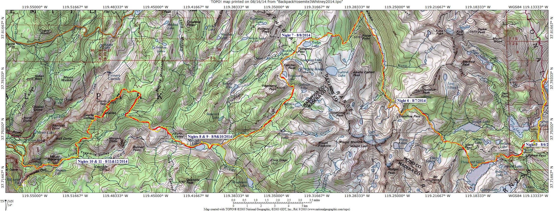 Yosemite Backpacking Route (Click on map for greater resolution) |
 Yosemite Backpacking Elevation Profile |
Photos and narrative were contributed by all of us:
Other Websites
By Bob:
Bob Phillips [phillips bob 27 at yahoo dot com - no spaces]
Santa Rosa, CA
August, 2012


